|
Situated in the south-west of
Iran, this province covers an area of 64236 sq kms. It is bounded on
the north by Lorestan, on the east by Chahar Mahal and Kohgilooyeh,
in the west by Iraq and on the south by the Persian Gulf. Khtizistan
consists of mountainous regions in the north and east, and also
plateau regions in the south, stretching from the southern parts of
the towns of Dezfool, Masjed-e Soleyman, Ramhormoz and
Behbahan to the river of Arvand and the Persian Gulf. The climate is
dry and semi-dry, save in few regions. The largest rivers are the
Karoon, Karkheh, Dez, Maroon and Arvand. The reedy marshes
called Hoors are numerous, the most important of which are Hoor
OL-Azim and those located in Dasht-e Azadegan and Shadegan
regions. The wildlife in these areas is of high significance to
biologists. The natural beauty of the marshes has endless
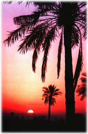
fascination for many. The plant life of the province includes konar
(Jerusalem thorn), oak, almond and palm trees. Archaeological finds
indicate that Khuzistan has been the borne of man ftom palaeolithic.
Elamite civilization coincided roughly in area with this
province. The ethnic groups are the Kurds, Arabs, Lors and
Azerbaijanis. The Arab tribes such as Bani Taraf and Bani Ka’b as
well as Bakhtiyari and Boyr Ahmadi tribes dwell in Khuzistan.
Persian and Arabic are predominant languages spoken with local
accents. The vast majority of the people are Muslims, mostly of the
Shi’ite sect. |
 |
 |
Being bounded on the south by the Persian Gulf,
this province, the seaports of which were primarily used for trade
with India, was an important centre for commercial activities
in the past. Today, in addition to important seaports used for
trade, Khuzistan’ s highways and roads play an important role in the
economy of Iran. The Trans-Iranian Railway spanning the
distance of 1391 kms between the two seaports of Bandar-e Torkman on
the Caspian sea and Bandar-e Imam Khomeyni on the Persian
Gulf, has spur lines to many of the provincial capitals. There are
two airports in the cities of Ahvaz and Abadan; the latter one
is international.Agricultural products are rich in variety,
the most important of which are wheat, barley, cotton, sugar beet,
sugarcane, and melons. The dams of Dez, Karoon and Karkheh provide
water for irrigation. Animal husbandry —particularly sheep, goat and
buffalo husbandry — and fishing are of high importance. Being an
industrial centre, this province has both light and heavy
industries, including large refineries, petroleum industry,
rolling mill, ironworks, sugar and paper mills and cementworks.
Lime, chalk, phosphate and sulphur mines are of high
significance. Due to the fertility of the soil , thriving industries
and oil resources it is figuratively called the Gold-bearing
province. Khuzistan consists of 15 cities. Ahvaz is the provincial
capital and the following are the other cities:Abadan, Andimeshk,
Izeh, Baghmalek, Bandar-e Mahshahr, Behbahan, Dezfool,
Dasht-e-Azadegan, Khorramshahr, Masjed-e Soleyman, Ramhormoz,
Shadegan, Shoosh, and
Shooshtar. |
|
Ahvaz
Dating
back to the second millennium BC, Ahvaz, the largest city of the
province, is one of the most ancient cities of Iran. The historical
monuments are numerous, of which the remains of a bridge, near the
present suspension bridge and the catacombs in the eastern part of
Abvaz belong to the pre-Islamic period. The mausoleum of All ebn-e
Mahziyar-e Ahvazi in Khorratn Kooshk and the mausoleum of Hazrat-e
Abbas in the village of Seyyed Abbas-e Abd oI-Khan having two lofty
minarets and a dome covered with beautiful tiles are among
historical Islamic monuments.The Karoon, the largest and the only
navigable river in Iran flows through the city and divides it into
eastern and western districts. The governmental and business sectors
are largely centered in the western district.Having a mild climate
in winter and in early spring, Ahvaz attracts a large number of
visitors each year. There are recreational facilities such as rowing
and motor boats on the Karoon. Bazaar, beautiful banks of the Karoon
and palm groves are among places worthwhile seeing.
Abadan
Situated 115 kms
south-west of Ahvaz on the Arvand Rood (Arvand River), Abadan is a
leading economical centre in Iran. Rich mineral resources contribute
to the importance of this major port. At night, the lights mirrored
in the water of the river afford an impressive sight. |
 |
|
Dezfool
It is located in the north of the
province, 150 kms distant from Ahvaz. The earliest evidence of
man found on the hill of Chogha Mish, 40 kms south-east of
Dezfool to the 6th millennium BC. This city was probably built
in the Sassanian period. Of the monuments belonging to the
Sassanian period are the palace of Karkheh, 18 kms south-west
of Dezfool and the remains of a bridge across the Dez River.
The architecture of the palace is of high interest to
visitors. The historical monuments belonging to the Islamic
period are Jame’ mosque (9th century) and the relics of
ancient mills. The restaurants serving regional foods are
among other attractions of Dezfool.
Shoosh
This town, the Biblical name of which
is Shushan is located in the west of the province, 110 kms
distant from Ahvaz. Being a city of great antiquity, it was
the capital of EIam and during the Achaemenid period it was
one of the four capitals. In the Parthian and Sassanian The
historical monuments are numerous and impressive. The
following are among the most important ones.The mausoleum of
Daniel (a Hebrew prophet during the Babylonian captivity).The
relics of the ancient temples in Haft Tappeh.The ruins of
Susa, belonging to the 5th millennium BC, are of high
significance to historical research. Iii the palace of
Apadana, going back to the Achaemenid period, the images of
the Javid (immortal) soldiers on the bricks and the image of a
lion in a naturalistic style are among the masterpieces of the
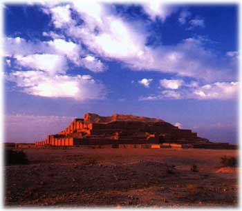
ancient art.The ziggurat of Chogha Zanbil is located 30 kms
south-east of Shoosh. This temple has the form of a terraced
pyramid of five successively receding storeys. In the fifth
storey the god of Elamites was worshipped. The ruins of an
Elamit city, dating back to the 13th century BC have been
found near the ziggurat. The city was destroyed by order of
Ashurbanipal. This ziggurat has been registered by the Unesco
as a historical monument.There is a museum in the town of
Shoosh in which historical objects, relics of ancient tombs
and coffins belonging to different ages are
displayed.
Souvenirs
The handicrafts produced in
Kbuzistan are rich in variety and famous for their delicacy.
The bed sheets, abas (men’s loose sleeveless cloaks), prayer
carpets, jajims (fine carpets made of wool or cotton), givehs
(light cotton summer shoes), goldware, silverware and
earthenware are beautiful handicrafts suitable to be kept as
souvenirs.Many visitors find the taste of the regional sweets
very pleasant. | |
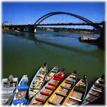
Khorrarmshahr
This leading port which stands at the
confluence of the Karoon, the Tigris and Euphrates, plays a
significant role in the economy of the province. A spur line links
it with the Trans-Iranian Railway. Local bazaar, vast palm groves
and the fishing boats on the river are very sightly. The distance
between Khorramshahr and Alivaz is 128 kms by land and 168 kms by
the Karoon River. The weather is mild in winter and muggy in
summer.
Izeh
Located in
the north-east of the province, it is a historic city that was of
high significance in the Elamite civilization. The ancient monuments
are numerous, indicating its greatness in the distant past and
attracting a lot of tourists. The following are among the most
important ancient monuments.
Eshkaft-e
Salman
Situated 3 kms south-west of Izeh, it contains four
reliefs dating back to the 7th and 8th centuries BC and belonging to
the Elamite civilization. These reliefs represent the ritual of the
people of that age. There are also epigraphs written in cuneiform
characters.
• KooI-e
Farah
It is located in the south of Izeh. In this place
there are six scenes carved on the rocks, representing the ritual of
offerings to the gods and general audiences with the King. Dating
back to the Elamite civilization, some of the reliefs include
epigraphs written in cuneiform characters.
• The village of Shami
This village, located 9 kms
north Izeh, contains relics of ancient buildings. A life-size bronz
statue of a Parthian commander found in the village indicates the
great dexterity of the craftsmen of that age. This statue is
displayed in the National Museum of Iran.
Behbahan
This town is situated in the east of
Khuzistan. It is said that iii the early 14th century, a city called
Arajan which had been built in the Sassanian period near the present
town of Behbahan, was ruined, as a result of which the people moved
into Behbahan. The ancient part of Arajan is located 12 kms
north-east of Behbahan on the Maroon River. The following are among
the important remains found in Arajan: a mausoleum in which there is
a bronz coffin, a golden ring called the ring of power with
beautiful designs and a brain cup, all belonging to the Elamite
period. The latter, having impressive caned designs and an epigraph
written in cuneiform, is world-famous.Shooshtar This town is located
in the north of the province, 90 kms distant from Ahvaz. Jaine’
mosque and a bridge called Shadorvan are among historical monuments.
The bridge having 16 mouths through which the river flows, goes back
to the Sassanian period.ages it was among the most significant
cities.
Masjed-e Soleyman
It
is the easternmost town in Khuzistan. The archaeological finds
suggest that it was probably the first capital of the Achaemenid
dynasty. The important historical monuments are as follows: Soffe-ye
Soleyman and a stony monument called Bard-e Neshandeh, 25 kms
north-east of the town, dating hack to the Achaemenid period. This
monument is a point of interest to tourists.
Bandar-e Mahshahr
It is the second greatest port in
Iran, used for the export of oil and natural gas. The petro-chemical
industry has contributed to the importance of this town. The coastal
area, particularly at fig ht,is very
sightly.
|
|