| Geography and History |
|
With
18050 Kilometres area, the province of Ardabil is located on the
north-east of Iran . It includes the districts of Ardabil,
Khalkhall, Meshkeen Shahr, Geirmi, Bilasavar and Pars Abad. The
historic and Islamic city of Ardabil is the capital of the
province.
The population of the province in 1996 was 1,168,000
from which 48.8% were registered as urban dwellers while 51.1% were
villagers and the remaining 0.22% were registered as nomad
tribes.
four districts of this province are located on the border
with the Republic of Azarbaijan, with a total border line of 282.5
kilometres length . The river Aras and the river Balha consist 159
kilometres of the border length mentioned above. Throughout two
checkpoints, named Aslandooz and Bilasavar, this province ic
connected the Republic of Azarbaijan, while Ardabil-Astara road via
Hayran, connects Ardabil to Rasht, Qazvin and Tehran .
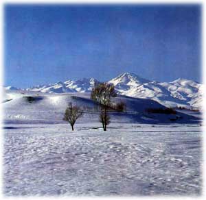
Ardabil
province enioys geographical and enviromental diversity. The
district of Ardabil is consisted mainly of mountainous areas,
including the famous mountain of Sabalan. the mountains Talesh and
Bozghoosh which surround this district. Most of this district
heights are above 3000 meters altitude, and the pake of Sabalan’s
hight is 4811 meters, while is located on the north-west of the
district and causes the temperate weather of the area. Generally
speaking, the district of Ardabil is known as one of the coldest
areas of Iran with a very cold weather for 5-8 months a year . Cold
winters and temperate summers characterise the climate of the
district.
Bilasavar District locates in a large plate, and it has
a warm summer and a temperate winter.
Parsabad-Mughan districtis
located in a large plate too, and its weather is temperate to warm.
The plate of Mughan is recognized as one of the most important
modern agriculture and animal husbandry of the country.
Germi
District is located between two low-hight mountain chains, and it is
warm in summer and temperate in winter.
Khalkhall District is a
mountainous area, so it has a very cold weather in winter and a
temperate in summer. It is usually covered with heavy snow and ice
for five months a year , which causes the road Asalem-Khalkhall, in
the mountainous area of Talish to be closed during this
period.
Mishkeen Shahr District is located on the western
outskirts of the mountain Sabalan, and it is very cold in winter and
mild in summer.
The history of the province of Ardabil is a part
of the history of Azarbaijan. Most Iranian historians believe that
the city was built by Firooz, the Sasanid king (457-489 AC), and the
city has a 1500 year history. But even earlier, Ardabil was a very
imporant city from the military and political points of view during
the Achaemenid period, which was a military base on the northern
border of the Persian Empire. according to Avesta, the Iranian
profit, Zoroaster was born near the river " Daei Yeat " which is now
named "Aras" , and he had written his book in Sabalan area, while he
began to propagate his religion in the city of Ardabil.
At the
time of the moslem Arabs invasion of Iran, (year 22 AH) the city of
Ardabil was the largest in Azarbaijan, which failed to the Muslims.
Between 257-317 AH it was the headquarters of the local government
of Bani Saj who changed their capital from Maragheh to Ardabil. And
the city of Ardabil remained the capital of Azarbijan until the
Moguls attack.
Shah Esmael, the Safavid king began his effort for
establishment of an Iranian united empire, then he settled in Tabriz
as his capital in 906 AH. During the Safavid era, Ardabil became the
most impotant city of Iran from the political and economic points of
view. The Significant location of Ardabil on the main trade road
between Iran and Europe had increased her impotance for trading silk
and other goods between Guilan in Iran and different parts of the
Europe.
The city of Ardabil now is one of the most important
cities of the province and Iran for its man historical elements,
specially the Safavid family’s shrines, its location near many
mineral-warm spring, and location on the main access road to the
Republic of Azarbijan. These have turned the city a tourism centre,
which is visited by thousands of tourists every year.
Among main
historical monument of this city, one can name its old bridges with
their special architecture, its historical places, significant
mosques, shrines, churches and other holy buildings, all with
valuable architecture.The significant architecture of commercial
unites, specially the traditional bazaar are attractive
too.
Furthermore, the natural attraction of the region and the
city, specially Sabalan marvellous outskirts, and the warm mineral
springs of Sareain from an environment suitable for tourists in
spring and summer . Moreover, Infact, environmental diversity of the
province Helped the province to have. province’s beautiful valleys,
attractive forests, wonderful lakes and many beautiful marshlands,
and landscapes. The lakes of Shoorabil and Neor are well facilitated
for tourism and are very attractive areas in summer, which can be
upgraded to be one of the most attractive tourist areas in
international level.
In addition to the tourism attraction of the
province, its significant location on the strategic border area as a
neighbour with the Republic of Azarbaijan, have well faciliated for
the development process of the province and the whole region. the
recent developmant of trade relations and communication between Iran
and the Republic of Azarbaijan have been significant for the
development of tourism and economy of the province of Ardabil,and
more development is expected in the future.
Main historical,
cultural and tourist characteristics of cities, towns and regions of
the province are as followings: |
| The City of Ardabil |
|
The city of Ardabil is located at
adistance of 639 kilometres from Tehran, the national capital, west
to the volcanic mount of Sabalan. The weather of the province varies
between extreme cold on the mountains, to moderate on the plains
during winter. The name of Ardabil came from an Avesta’s (Theholy
book of Zoroasterians Concient Iranians) word, "Artavil" which
meantal a holy place. Some historians the establihments of Ardabil
to "Bazan Firooz" . Archaeologists have recently found some
historical elements in Nameen, a nearby town, which belong to the
12th-16th century BC. The Oratoie epigraph while belongs to the 7-9
centuries BC, and was found in Arasbaran, mentions that civilized
people lived there in the region of Ardabil. The most important
places to visit in Ardabil ars as follwing.
Neior lake which is
located 48 kilometres south-east to the city of
Ardabil.
Shoorabil lake which is located south to the city of
Ardabil.
marshlands of Ganjgah, Nooshar, Shoorgul, Molla Ahmed
and peer-el-Qeer.
River sides of the river (Roodkhaneh) Baliquli
Chay.
Wild life and forests of Sabalan outskirts.
water fall
Goorgoor on Sabalan.
hot water springs in Sare-Ain, west to
Ardabil.
mineral springs in Bila Darreh.
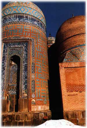
Shaykh Safi Tomp
complex which is located inside the city Ardabil.
Shaykh
Jebrayeel tomp which is located in Kalkhouran village.
Imamzadeh
Salih Tomp which is located inside the city of ardabil.
Masajid
(mosques) Mirza ali kbar, Jumaa. and the church of Maryam
Moqaddas(holy Mary) which are located inside the city of
Ardabil.
Old Bridges og Qara Sou, Eidi Gouz, Ibrahim Abad,
Yaqobeyeh, Sayed Abad, Samian Kalkoran, neer, Almas,Shahr Chay and
Guilandeh.
Old Bathes of Och Doccan, peer Zargar, Mirza Habib,
Haj Skaykh, Mulla Hadi, Safavieyeh and Haj Raheem.
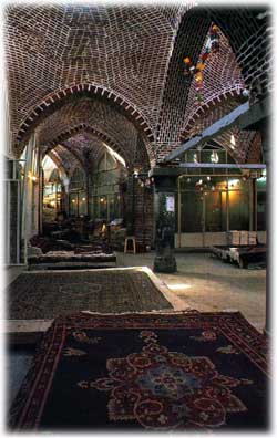
The Old Bazaar
Complex.
Old Houses of Ardabil.
old Hills of Qara Shirvan,
Naranj Tappeh, Sarqeen, Aq Imam, Gour Tappehsi, Olo Tappehsi, Karkaq
Tappeh and Saien Tappeh.
hold Cemetreis of Sham Asbi and
Karjan.
Tower of Shater Gunbadi which is located 8 kilometres to
Ardabil.
Stone cave of Dakhmeh Sangi which is located near Veind
village. |
| Mishkeen Shahr |
|
The town of Mishkeen Shahr is located
839 kilometres to Tehran and near to the Sabalan high mountain. The
weather of this town and the district of Mishkeen Shahr is moderate
mountainous. It was called "kheyav" in the past.
The most
important places to visit in the district of Mishkeen Shahr are as
following.
Hot water springs of Moveel and Ilan Dooghan located
in the sub urbs of the town.
qara Sou River Sides.
Water
Qotoor Soo spring located 25 kilometers to Mishkeen
shahr.
Qaynarjeh spring located south-west of Mishkeen
Shahr.
water Ilavand spring located 15 kilometers to Mishkeen
Shahr.
Old Castle of Mishkeen Shahr.
Aghcheh castle located
near Cheteen Darreh, near Mishkeen Shahre.
Deev castle located in
kevich.
Hill Qanbar locvated in Anaar village.
Stone epigraph
of Shapour sasani in Mishkeen Shahr.
Old cemetry Anaar.
tomb
of Shaykh Haydar in Mishkeen Shahr.
Imamzadeh Saeyed
Solayman.
Masjid (mosque) Jannat Sara which is located in cide
the town of Meshkeen Shahr.
Shrine Hassan Dash located in the
twon Mishkeen Shahr. |
| Khalkhall |
|
The
twon of Khalkhall is located in a mountainous highland, 549
kilometers north-west to Tehran. The weather of the district od
Khalkhall is very cold on the eastern part, and moderate in the
north and the south. The most important tourism attractions of the
district are as following :
Abgarm Khushnameh hot water spring
and hot Mineral Water in Garmuhaneh village.
Imamzadeh Meerzaman
and Sayyed Ibraheem located in khams village.
Shrine or Danyal
which is located in khanqaah village.
Mosque of Jami and Masji
Noor located in khams village.
Ghaar Tarikhi Yakhkan (historical
cave) which is located in Gandum Abad village.
Haft Khaneh cave
located in Garmkhaneh village. |
| Dashte Mughan |
|
There
is large plain located between Aras river (south) and the northern
parts of the mountain chain of Talish while is called Mughan, which
expanded from the outskirts of Sabalan mount to the Caspian costs.
Today large plain includes three districts called; pars Abad, Beeleh
Savar and Guirmi. This green and pleasant plain includes many
natural places, which worth to see, as following:
Aras River
Sides.
Shahrak lake in pars Abad.
Great complex and integrated
agriculture, industry and animal husbandary in Mughan.
Oltan
castle which is located north to pars Abad .
Qiz Qalasi (the Girl
Castle) which is located in Guirmi.
the Historical Bridge in
khuda Afareen.
Kharman Hill which is located in Shaykhlar village
in Germi.
Naader Hill in Aslandooz.
Old cemetry in
Aslandooz.
Qarlooja Tawer which is located on the road between
khormaloo and Aslandooz. |
| Wild life |
|
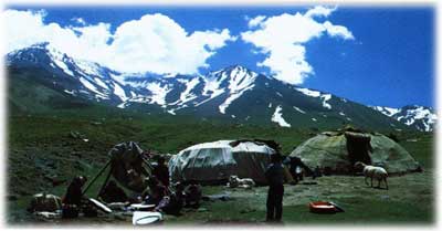
The province of Ardabil is significant
from the wide life point of view. The mount Sabalan is the hostle of
the wild animals of view . There are many protected wild life zones
on the highlands of the province located on the outskirts of the
mount Sabalan, the most importants amang them are:
Sheerwan
Darrehsi, Moweel, Hooshang Meydani, qara Gouel, Khorosloo Mughan,
Aqababa, Hajiloo, Tabnaq, Hassan Darrehsi, arbab kandi, and the
protected zone neour which host wild animals such as wild goat, pig,
brown bear, grey bear,fox, wolf, ram, Armenian ewe and rabit live in
this province . birds such as partridge and egle can be found
too. |
| Travel and Stay in the Province |
|
| All
districts and towns of the province are well connected with each
others as well as other cities and towns of Iran by a network of
roads and traveling on them is very comfortable. Only in the
district of khalkhall, travelling is difficult because of the
highlands and the snow fall for a long cold season causes road
blocage. All towns of the province and specially the city of Ardabil
is well facilitated by networks of transportation and health
facilities, so traveling and staying in most of the towns on the
province is enjoyable. It should be mentioned that most facilities
are found in the provincial capital Ardabil, but all other towns
enjoy acceptable facilities, such as restaurants and gusthouses.
Ardabil Airport and the air port of Dashte Mughan provide trips to
Tehran and some other Iranian
destinations. |
|