irman3

Gilan


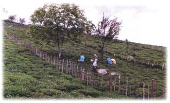
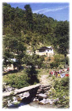
The coastal plains of the Caspian Sea, with more than 600 kilemeters length, mountainous slopes and beautiful towns and villages, kind and hospitable people, are some of important recreational regions of Iran. 
There are different and enough  accommodation facilities as well as other necessary services providing suitable conditions for tourism. There are in the coastal areas of the Caspian Sea, dense forests of different species, forest parks, sandy beaches, clean waters, and several large and small rivers, that totally have created a beautiful and eye-catching natural landscape. The large and small cities are mostly located beside the coastal road and are centers of socio-economic activities of the region. From border town of Astara in extreme northern  coastline of Iran to the banks of Atrak River in south-east of the Caspian Sea, there are numerous cities and tourism centers with necessary facilities like Talesh, Bandar Anzali, Rasht, Lahijan, Ramsar, Chaloos, Nowshahr, Babol, Amol, Sari, Behshahr, Gorgan, and Gonbad-Kavoos.


In addition to recreational characteristics of the Caspian Sea coasts, there are other worth-seeing places. Among them, the existence of the historical sites in the cities of Rasht, Fooman Lahijan, Gorgan and Gonbad Kavoon may be pointed out. In the cities of the Caspian Sea coastline, different wooden, Bamboo, and mat-like products are supplied in huge quantities. Vast fields of rice, tobacco, tea, oleaginous seeds, cotton, and citrus orchards along with beautiful wooden houses, have created a very interesting social life and livelihood which is worth-seeing for every tourist.

Summary: The regional plan for the development of Gilan and Mazandaran is one of the first structural plans covering the region which has been prepared to incorporate precise data about the present condition of these two provinces and outline the prospect for their development. Factors affecting population, economic potentials, tourist facilities, etc., as well as the unique geographic attributes of Gilan and Mazandaran are among the issues that have been duly examined in the study.

Text: Structural urban planning in Iran has a relatively long history but the plan for the Gilan and Mazandaran region, prepared by the Center for Study and Research of Urban Development and Architecture and introduced in this article in brief, is a new undertaking, in terms of subject and content, and is a turning point for regional structural planning in the country.

Gilan and Mazandaran were selected for this study for two reasons:

  1. The provinces exhibit a similar an unified structure despite variations in activities and in geography and environment.
  2. The region's rapid development over the past decade has inflicted severe damage to the sensitive and fragile environment thus it has become a national imperative to regulate future developments in this part of the country. Attention has to be specially directed to the reorganization and adjustment of the trend of population settlement in the area.

Present Condition of the Region

With an approximate area of 60,000 square kilometers, Gilan and Mazandaran occupy 3.7 percent of the country. In 1986, the provinces had a population of about 5.5 million, or 11 percent of the country's total population. Bordering the Caspian Sea, the region has a singular beauty. It has moderate weather and receives adequate rainfall. Its diverse topography gives it a beautiful natural landscape. Its forests are the only ones in the country that have been commercially explored. It holds 40 percent of Iran's pastures and 8.5 percent of agricultural lands.

With the region's geographical diversity and abundance of natural resources, unique patterns of population settlement and spheres of business activity have resulted. Its vast economic possibilities served as a magnet for people and the area has become quite congested with a density of 90 persons per square kilometers, three times the national average. The settled areas however, are scattered throughout the region although there is a relatively lower average of urban settlement, about 27,000 persons per town, which is half of the country average. The scattering of numerous towns and villages expressly points to the region's special characteristic (see charts 1 and 2). Another significant factor is that 70 percent of the area in Gilan and Mazandaran is mountainous, hence the inhabited areas are spread on the plains which comprise only one-third of the region.

The high density of inhabitants versus the limited area available for settlement, with townships far from each other, give rise to abnormal situations. The settlements cause environmental damage; there is also the fact that there are no major city centers capable to render services in the region as the towns are small and far in between. Gilan and Mazandaran therefore remain dependent on Tehran for many special services although the region enjoys extraordinary natural and economic potentials.

The absence of town planning and the exploitation of any available property to accommodate settlers, the invasion of the natural plateau, and congestion generated inadequacy and disruption in the activities of towns all posed problems in their management. The total urban population of Gilan and Mazandaran in 1986 was about 2 million occupying an area of 76,000 hectares. As a result, the average gross density was 27 persons per hectare in urban regions. These are factors exhibiting the unhealthy condition that threatens Gilan and Mazandaran.

Moreover, Gilan and Mazandaran are prone to earthquakes, and the tremor belt extends from Gonbade Kavous in the east to Noor and from Tonekabon to Hashtpar. The region also gets inundated by the rising Caspian Sea and the excessive flooding causes a lot of property and crop damage.

Given the small sizes of villages and towns (21 towns in the he total region plus villa townships and private areas) and their distance from each other, Gilan and Mazandaran have become very vulnerable against natural catastrophes as effective measures cannot be put in place to combat damages caused by the rise in the sea level, flooding, etc., and any rescue operations, once calamities strike, have proven to be quite costly.


The above-mentioned factors have also affected activities in the tourism and industrial sectors. Industrial operations are likewise concentrated on the plains, similar with tourist facilities. But while the region is rich, there is a lack of a system to organize, control, and direct the proper utilization of these resources. A case in point is the development of tourist facilities. Townships and private villas were hastily built along the coast between Ramsar and Babolsar in order to accommodate more tourists that in 1989, there were about 70 half-completed towns in the vicinity.

This development scenario exposes the sensitive natural environment to misuse, misappropriation and damage, and also creates insufficiencies and disruptions in the region. Statistics show that forest areas which have been converted into farm lands and orchards have increased ten-fold compared to 60 years ago and the decline in jungle coverage definitely has environmental repercussions.

Compared to figures in 1963, the total forest area has been cut down to half, and each year, about fifty thousand hectares more are ruined. This trend affects the production of wood but more importantly, it disturbs processes for propagation, evolution, and the habitat of many living species.

Aquatic areas like the Anzali Pond, marshes and watersheds are drying up. The present area of the Anzali Pond has been reduced to one-fourth its original size. Apart from its beautiful surroundings, this pond is one of the most important retreats for marine fowls in the country, a lot of which are now on the verge of extinction. Accumulation of sea deposits in the pond has resulted in its premature aging and drying. And as it borders agricultural lands, it is also being polluted by insecticides and fertilizers. The lack of an efficient sewage treatment system also contaminated the Anzali Pond and factory effluent from Rasht and Anzali have further contributed to its destruction.


Unregulated activities related to tourism has pulled the prices of real estate properties upwards. The high prices have likewise encouraged the conversion of agricultural lands for the building of houses and other tourism-related businesses.
Out of 78 towns in the region, 59, or 75 percent of the towns, had less than 25,000 persons in 1986. Rasht, the largest town in Mazandaran, had a population of 300,000. At that time, Gilan and Mazandaran ranked second to Tehran in terms of population density. At present, based on total population, Gilan is eighteenth and Mazandaran holds the twenty fourth place in the country (see charts 3 and 4).

Policies and Suggestions Proposed by the Regional Plan


The scenario presented above clearly shows that from the viewpoint of `environmental management', which, incidentally, is the main theme of the structural plan, the main problem that plagues Gilan and Mazandaran is how to organize its numerous and scattered townships.

Protection of the natural environment and the development of suitable conditions for implementation of activities are the objectives of the plan, and concentration and centralization have been recommended as solutions to the region's problems. The study has identified as interrelated goals the protection of natural resources, agricultural lands, historical and cultural heritage; the adoption of safety measures against natural catastrophes; and adjustments in the patterns of population settlement and activities.

The plan outlines the following modes of action

A. Urban Expansion:

  1. Considering the special characteristics of the region, the 46 towns which can absorb a population of more than 25,000, are divided into three groups in year 2011: small towns (with a population of 25,000 to 100,000), medium sized towns (with a population of 100,000 to 250,000) and large and very large towns (with a population of 250,000 to 500,000 or more). Based on activity, the towns have classified into five groups: commercial, tourist, agricultural, industrial and mining towns. The nature and volume of services to be rendered by each category have also been outlined so that these factors will serve as bases for economic development, capital investment and the method of project implementation by the responsible organizations (see map 1).

  2. The boundaries of towns (particularly those located along the coastal area which form an integrated colony) have been determined and suggested to be followed in planning for the development of the region in general and each town in particular (see map 2).
  3. Due to the haphazard and destructive expansion of majority of the towns, maximizing the use of town space, establishing a sort of cohesion and integration in their structures and serious protection of the lands surrounding the towns, have been set as the main elements to consider in the preparation of structural plans for smaller towns. Moreover, due to environmental considerations and the limited space available for setting up new communities, the establishment of new towns has been prohibited.
  4. Any appropriation and invasion of the coastline area by the private sector for private use, or the creation of service centers around highways and main roads, specially along the coastal road, has been forbidden and plans for smaller towns have to be drawn in such a way as to incorporate such limitations.
B. Industry:
  1. Suitable locations have been recommended to centralize industrial operations and the structural capacity of the area, economic structure, population, environmental potentials, etc. are to be given due attention by responsible organizations when planning for industrial townships.
  2. Expansion of industrial plants which violate the guidelines set by the Environment Protection Organization are unauthorized and therefore, banned.
C. Tourism:

The region is undeniably a tourist haven but so far, the development of tourism in this area has not been undertaken properly, hence, its potentials in this field have not been realized fully. The haphazard construction of tourist facilities and the unsystematic expansion of towns along the main tourist routes has had a very negative effect. Therefore, the preparation of a comprehensive plan with the cooperation of authorities and organizations under the auspices of the Ministry of Culture and Islamic Guidance has been considered as a definite necessity and the following points have been suggested to be included in the plan:

  1. Tourist facilities must be within the areas duly identified as "tourist centers" in the structural plan, in order to organize these facilities and avoid inflicting harm to the environment (see map 4).
  2. national parks must be established in suitable localities in the region, particularly at Gilan.
  3. To prevent the random building of villas and townships along the coastline area and mountainous regions, the plan has proposed the setting up of camps and other accommodation facilities, to be available to tourists at affordable prices.
  4. Regions which have tourist attractions but have remained unexplored, such as summer resorts at Alborz slopes, locations for winter sports, and historical sites have been pinpointed as major development targets in the plan.
  5. Establishment of an efficient system of transportation is necessary to attract more tourists and expansion of the transportation system (roads, railways, sea and air lines) can be implemented with the cooperation of concerned authorities and organizations.
The structural plan recommends these measure to meet this objective:
  • Extension of the coastline roads to reach Khorasan Province,
  • Building of new ports to extend water lanes to and from the region,
  • Expansion of the present railway system, linking Mazandaran railways to Gilan, Khorassan and Semnan and providing rail lines in the Qazvin-Rasht area, and
  • Enhancement of air transport networks and expansion of the airports in Gilan and Mazandaran, specifically the Rasht and Sari air terminals.


Home > About Iran > Gilan


Copyright © 2008 Iranparstour.com. All rights reserved.